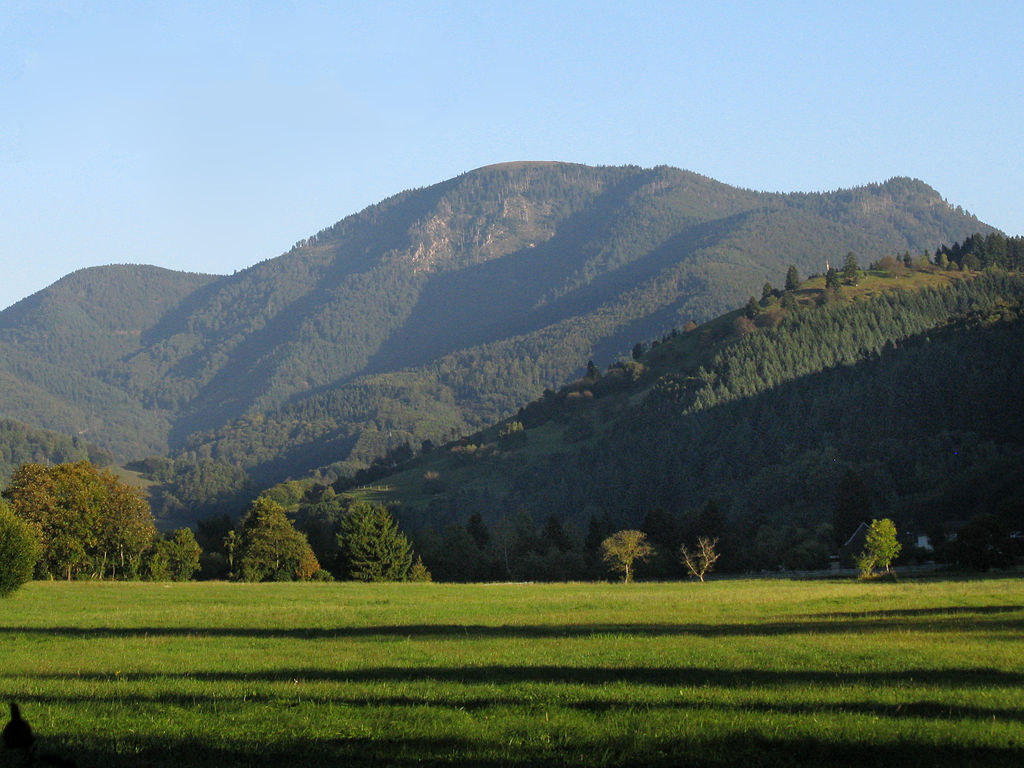
Awesome that you are checking the routes! I am so excited for the picnic and to see what the day brings :). You should not worry, even though Hohe Kelch seems to be remote and hard to reach, there are plenty of option from very easy 20min hike to longer adventures. For sure, there is something for everyone!
Hohe Kelch is a lovely destination for reaching up Belchen. Its beautiful and inviting meadow has offered us a snack break for so many times, as well as the panoramic view of south Schwarzwald and Eastern wall of Belchen itself. Sometimes Alps are visible as well, from Zugspitze to Mont Blanc! I could not think of a more ideal place to enter thirties :). If you have been to Hohe Kelch before, for sure you know what I am talking about. If not, I am beyond thrilled to show you around! I invite you to explore a small description of routes I think might be interesting to take. Most of them I hiked myself at least once, so enjoy and I am excited to see you up there!
Coming by public transport:
There are several decent options how to reach Hohe Kelch/Belchen by public transport, varying from very easy to more challenging routes. Public transport offers flexibility with choosing two different routes for ascent and decent to Hohe Kelch and could be a nice opportunity to have a longer hike in this beautiful area. Use this resource as an inspiration :).
Belchen Talstation – Hohe Kelch (very easy to easy)
You can reach Belchen Talstation by bus from Bad Krotzingen/Münstertal (291 Bad Krotzingen/Münstertal – Belchenbahn, take until Belchenbahn OR Wiedener Eck (not all busses go through to Belchen), then take 7306), from Titisee (7300 Titisee, Bahnhof – Zell (Wiesental), Bahnhof, change at Aitern, Abzweigung to 7306 direction Wieden (Schw), Wiedenrütte and drive until Aitern, Multen), from Kirchzarten (7215 Kirchzarten, Bahnhof – Todtnau, Busbahnhof, change at Todtnau Busbahnhof to 7300 direction Zell (Wiesental), Bahnhof, change at Aitern, Abzweigung to 7306 direction Wieden (Schw), Wiedenrütte and drive until Aitern, Multen), from Basel (S6 to Zell, bus 7300 Zell, Bahnhof – Todtnau, Busbahnhof, change at Wiese to 7306 direction Aitern, Belchenbahn Talstation and drive until Aitern, Multen).
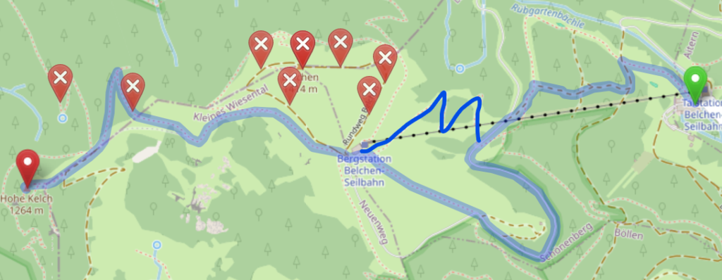
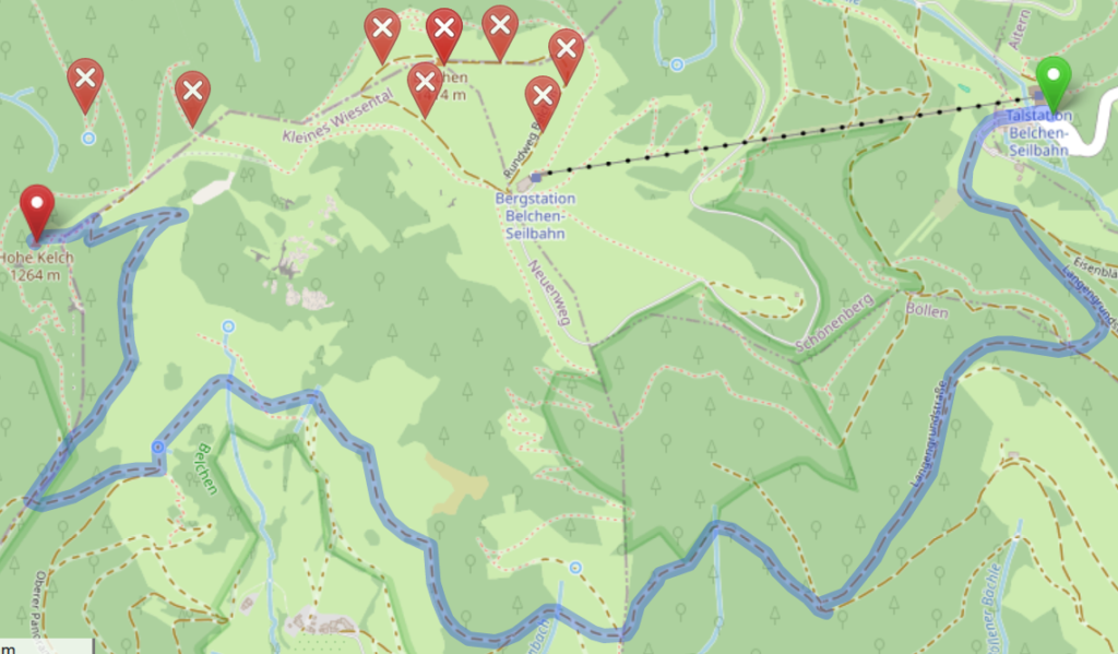
From Belchen Talstation you can choose to walk 3,8-5,4km or take a cable car to Belchenhaus and then walk. Please have a look at the 3 suggested routes and choose the most fitting for your hiking mood. There are many alternative routes and shortcuts, do not be shy to explore the map and optimize the route for your own taste! Here I used www.openstreetmap.org route generator, however, it is not always the best answer :).
Route 1: easy + very scenic 3,8km 40-60min hike through Belchenhaus itself. From there Hohe Kelch is a short very scenic walk away. On a clear day you can even see Alps from there!
Route 2: easy + scenic 5,4km 1,4-2h hike without reaching Belchen top, trailing at its southern face with a scenic view to Schwarzwald. Total high ascent ~450m.
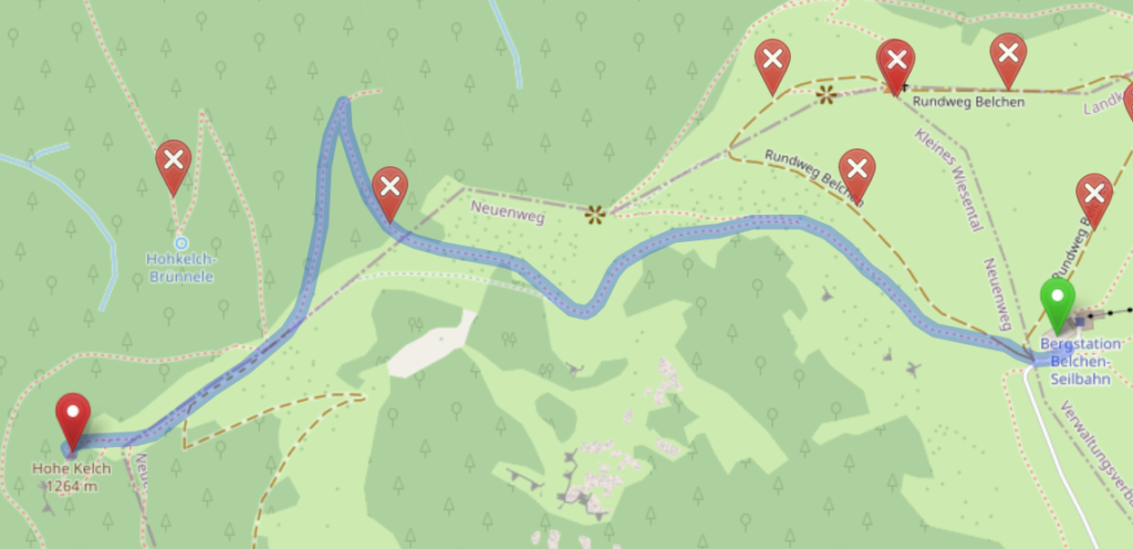
Route 3: very easy + very scenic 1,5km 10-20min walk in case you wish to take the cable car. From the Belchen it is a very short walk down the hill until the Hoche Kelch.
Haldenhof – Hohe Kelch (easy to fairly easy)
You can reach Haldenhof from Müllheim (Bus 111 Müllheim – Neuenweg Haldenhof until Neuenweg Haldenhof), from Basel (S6 to Schopfheim, then taking a bus 7310 Schopfheim, Busbahnhof – Neuenweg (Kr LÖ), Haldenhof until Neuenweg, Haldenhof). From then on it is a comfortable hike to Hohe Kelch.
Route 4: easy + scenic 4,2km 1,5-2h hike. The pathway is very easy to follow, route is not steep at all with moderate ascent and only few steeper parts. Could be biked as well I assume (however never tried). In total around 450 high meters. It is usually the route of choice for us for a quick and painless walk to the Belchen :).

In case you would like a small challenge on this route, consider taking a d-tour (marked red) around the rocky part of the Hohe Kelch itself. It is a tiny bit longer and steeper, however it offers a fantastic view to Münstertal and Rhine valley. Highly recommended!

Sulzburg – Hohe Kelch (Moderate)
For those wishing for a longer hike following less known (but absolutely worth exploring) hiking ways in Schwarzwald, I could not recommend more this option. It is one of my all time favorite, even though it is relatively long.
You can get to Sulzburg by taking a bus 113 from Heitersheim train station, or biking from Heitersheim (roughly 6km). Biking has an advantage, as you can bike part of the hiking route and leave your bike at Waldhotel, saving yourself around 3km of a hike one way (downside being, that you should come the same way back to collect your bike).
Route 5: moderate + very scenic 16km (13km from Waldhotel) 4-5,5h hike. The red circle is Waldhotel, orange circle is Kälbelescheuer (they serve food+drinks until 19:00). The route is leading until Haldenhof, then joins route 4 to the final leg.
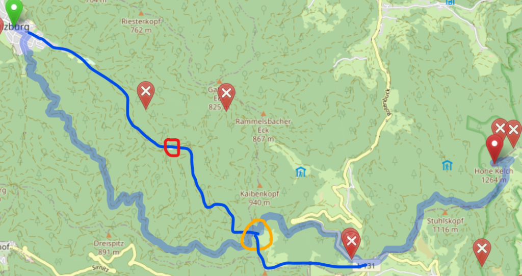
The route until Kälbelescheuer is a bit more tricky to find, if you would consider this route, please do let me know, I will share a detailed map with you.

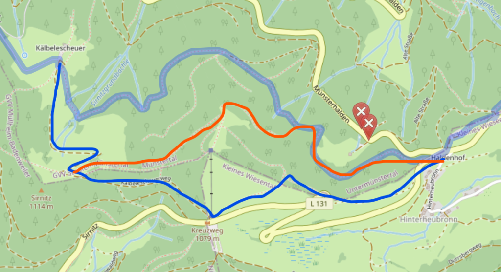
From Kälbelerscheuer I would follow to the Kreuzweg (more high meters, however very easy to follow) marked in blue and then to Haldenhof and Belchen or follow the ridge shortcut, marked in orange (not marked at all, might be harder to follow, slippy in wet conditions, would recommend only for experienced hikers).
Münstertal – Hohe Kelch (Hard)
For those wishing for a real challenge, ascending from Münstertal direction will definitely offer it. While the distance is similar to route 5, westward face of Belchen is a quite steep climb. You can take a train from Bad Krotzingen toreach the end station in Münstertal, from there you can hike/bike to Mulden to start the route upwards. We usually go until Mulden by bike, and leave it at the end of the valley to spare ourselves a relatively boring walk Münstertal-Mulden.
Route 6: hard + very scenic ~8km (from Mulden), ~3h
The first leg of the hike is very idyllic, with rolling hills at the end of the valley, grazing fields and settlements. It is a fairly easy start, not so hard to follow.
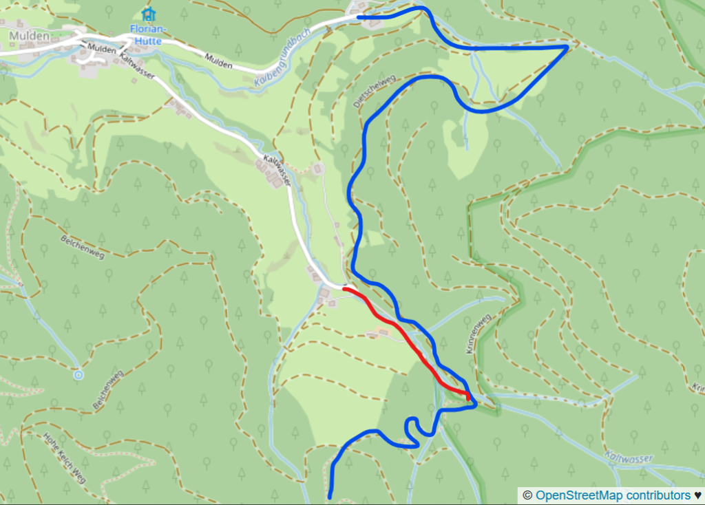
However, soon after the road will start to get steeper and more wigglier. There are several roads intersecting, however the route is relatively easy to follow. The final leg goes straight to Hohe Kelch.

In case you would like to prolong the hike and visit Belchen before reaching Hohe Kelch, you can make a d-tour, here marked in orange. Going to Belchen will add another 3-4km, high meters and another hour or so to the route.

There are many more routes available to reach Belchen/Hohe Kelch. Here are just a few that I have tried myself and thought are worth recommending. Feel free to explore the maps and the area to create the route best suited for your liking. The Belchen massive is indeed very scenic and I am sure everyone could find something fitting their fitness level.
Enjoy and do not hesitate asking question in case you would need help!
More information on some bus lines:https://rvl-online.de/liniennetz-fahrplan/linien/
Coming by car:
Coming by car makes things much more flexible and easier, you can modify the route depending on where you would chose to park. Generally every route mentioned above is available as well, however they might be adjusted depending on where you park.
For very easy routes, you might want to consider route 3, with least distance and high meters. Routes 1+2 also offer a fairly easy alternatives. For all 3 of the routes you should be able to park at Belchen Seilbahn Tahlstation.
There is a possibility to park at Haldenhof as well, however, there are very few parking spots and they all might be busy later in the morning. Parking at Kreuzweg is a great alternative. It adds additional ~1,5km to the route, but the extra distance rewards with fantastic scenery. From Haldenhof and Kreuzweg, you can embark on the route 4 (for extra piece from Kreuzweg, look at route 5).
Another great opportunity is to park at Kälbelescheuer, which is a restaurant and could offer an opportunity for a meal on your way home (it is open only until 20:00).
For routes 5 and 6, there are plentiful options for parking, both in villages or up in the valleys.
P. S. Most likely myself I will be taking route 4. Anyone wishing is welcome to join me on the hike itself :). Otherwise we see each other on Hohe Kelch!
P.P.S. Of course the invitation is extended to all of your family or whomever would like to join! Feel free to bring friendly doggos or other pets that might enjoy hiking (once we met a hiking donkey on Hohe Kelch!).
